Typhoon No.4 Narra: Update 24 August, 2026
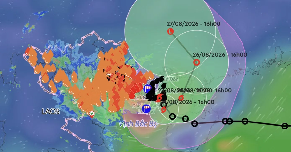
On the evening of August 21st, the tropical depression in the northern Gulf of Tonkin strengthened into a typhoon, becoming the fourth typhoon of 2026, with the international name Narra. If you are currently in or heading to Northern Vietnam, please be aware that this storm has brought unusually prolonged heavy rain and strong winds to the region. Here is everything you need to know about Typhoon No. 4, internationally known as Narra, to keep yourselves safe and adjust your itineraries accordingly.
Recent Developments and Current Status
.webp)
Latest update from the National Center for Hydro-Meteorological Forecasting, at 7:00 AM on August 23rd, the center of storm No. 4 was located at about 20.7 degrees North latitude – 107.8 degrees East longitude, over the sea area of Quang Ninh – Hai Phong. The storm center was approximately 100km east of Quang Ninh, about 120km east of Hai Phong, and roughly 70km north of the Bach Long Vi special zone. The strongest wind near the center of the storm is strong at level 8 (62-74 km/h), gusting at level 10.
Forecast: Path and Intensity
- Immediate Outlook: Typhoon No. 4 is moving very slowly—only about 3km/h—in a South-Southeast direction. The storm has been described as having an "anomalous" path, constantly changing direction due to a lack of stable guiding currents. According to Mr. Mai Van Khiem, Director of the National Center for Meteorological and Hydrological Forecasting, the storm is operating within the Intertropical Convergence Zone (ITCZ), where the large-scale conduction field is relatively weak, preventing a stable path from forming.
- Intensification Forecast: By 1:00 PM on August 24th, the storm is forecast to strengthen to level 9, with gusts of level 11. The storm is expected to maintain this intensity through August 25th.
- Future Path: By 1:00 PM on August 25th, the storm is expected to move East-Northeast at 3-5km/h over the eastern Gulf of Tonkin, about 160km east of Bach Long Vi, with winds of force 9 and gusts of force 11. The storm will then weaken into a tropical depression by August 26th as it moves toward the Leizhou Peninsula (China).
- Weakening: From 72 to 96 hours later, the tropical depression is likely to move northward, then North-Northwest, traveling about 5km per hour and gradually weakening into a low pressure area.
Impact Forecast for Vietnam
Sea Conditions
The maritime environment will become highly dangerous, particularly affecting island tourism and transit.
- Wind, Waves: Risk of strong winds at level 6-7; near the storm center level 8-9, gusts at level 10-11; sea waves 2-4m high; very rough seas.
- Affected Areas: The Gulf of Tonkin, including Bach Long Vi, Van Don, Co To and Cat Hai special zones and Hon Dau island, as well as coastal areas of Quang Ninh and Hai Phong. The disaster risk level is forecast at Level 3.
Land Impact
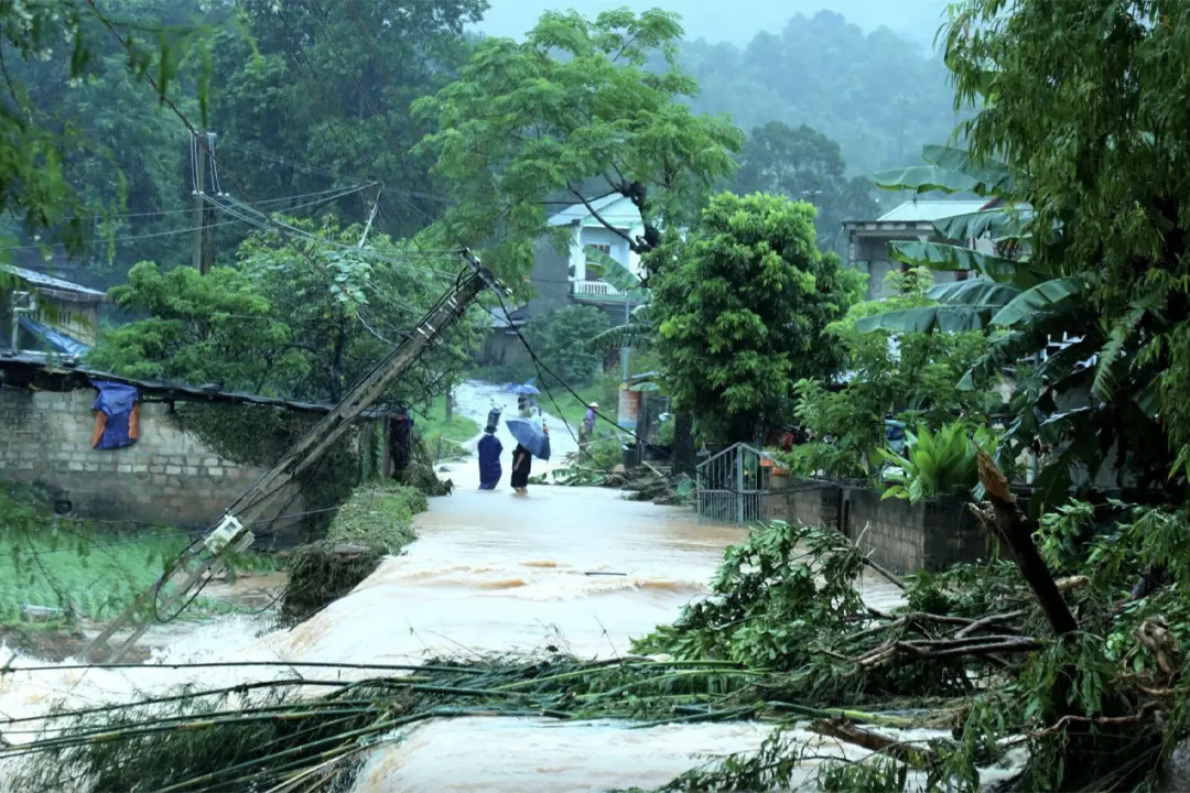
For the coastal mainland area, the affected areas are the coasts of Quang Ninh and Hai Phong provinces.
Risk from the afternoon of August 23rd, strong wind level 6, gusts level 7-8; sea waves 2-3m high.
The main impact is that strong winds can blow off roofs, damage temporary structures, break down green trees and billboards; affecting electricity, communication and traffic systems.
Regarding heavy rain on land, the affected areas are the Northeast region, the southern part of Phu Tho province, and Thanh Hoa.
Risk, from the night of August 21st through the end of August 24th:
| Region | Rainfall |
|---|---|
| Northeast, southern Phu Tho, Thanh Hoa | 100-200mm, locally over 400mm |
| Quang Ninh, Hai Phong | 250-350mm, locally over 600mm |
| Lang Son, Bac Ninh |
200-300mm, locally over 500mm |
Record rainfall has already been observed: Mau Son Station (Lang Son) recorded 452mm, Ban Chat Station (Lang Son) 399mm, Khe Mai Station (Quang Ninh) 334mm, and Cua Ong Station (Quang Ninh) 331mm as of the morning of August 23rd. The main impact is prolonged heavy rain may cause flooding in urban areas, industrial parks and low-lying areas; increase the risk of floods on small rivers and streams, flash floods and landslides in mountainous areas; affect traffic, agricultural production and people's lives.
Recommendations for Travelers
Safety must be your top priority. Typhoon Narra is an unusual storm that is moving very slowly and constantly changing direction, making it particularly unpredictable. Please adhere to the following guidelines:
- Cancel Island Excursions: Do not attempt to travel to or from islands like Co To, Cat Ba, or Quan Lan. Ferry services will be halted, and the seas are unsafe for any recreational boating or paddleboarding. The Gulf of Tonkin, including Bach Long Vi, Van Don, Co To and Cat Hai special zones, will experience very rough seas.
- Postpone Mountain Trekking: Avoid all hiking, camping, and trekking activities in the northern mountains. Heavy rain drastically increases the risk of flash floods near streams and landslides on unpaved trails. Authorities have already evacuated 2,965 households, including 2,736 in Lang Son, due to landslide and flood risks.
- Stay Away from the Beach: Coastal areas will experience dangerous surf, high winds, and storm surges. Swimming is strictly prohibited during this time.
- Stay Informed: Monitor updates from official sources, such as the National Center for Hydro-Meteorological Forecasting or local authorities, for the latest on service restoration and alternative travel options. The storm's path remains highly unpredictable and may change direction multiple times.
- Adjust Itineraries: If you are currently in Quang Ninh, Hai Phong, Lang Son, Bac Ninh, or mountainous northern provinces, consult with your hotel regarding safety protocols or consider moving inland to safer regions until the storm passes. Heavy rain is expected to gradually ease from the night of August 24th.
If you are planning a trip to areas affected by the storm and have already made a booking with a tour operator, you may want to consider changing your itinerary or requesting a refund/cancellation. We support refunds in the following cases: 1, the service is cancelled by the provider due to the storm; 2, the cancellation time meets the refund conditions listed in our refund/cancellation policy.
Conclusion
Typhoon Narra is a significant and highly unusual weather event that requires immediate attention from anyone traveling in Northern Vietnam. Moving at a snail's pace—only 3km/h—and constantly shifting direction, this storm has already dumped record-breaking rainfall across the Northeast region. While it may require you to pause your adventures temporarily, making smart, cautious decisions now ensures you can continue exploring safely once the skies clear. Stay indoors, stay informed, and stay safe.
Source: Vietnam's National Center for Hydro-Meteorological Forecasting, VNExpress, Dân trí, Lao Động, VietnamNet, VietnamPlus, and weather experts as of August 23, 2026.