Overview
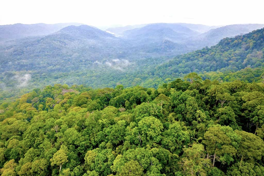
Bu Gia Map National Park is more than just a protected forest; it is the largest contiguous primary forest in Dong Nai Province (previously the old Binh Phuoc province), representing an invaluable genetic repository for the flora and fauna of the Southeastern region. Unlike the bustling waterways of Ninh Binh or the limestone seascapes of Ha Long Bay, Bu Gia Map National Park offers a "Price-to-Performance" sanctuary of raw, untamed nature that remains largely untouched by mass tourism. Covering over 25,600 hectares, the highest point in the area is 700 meters above sea level. The landscape is defined by a dense, pristine primeval forest regarded as a primeval forest ecosystem on low hills with altitudes under 1,000 meters, teeming with hidden waterfalls and a mysterious microclimate that nurtures rare wildlife, including the elusive yellow-cheeked gibbon and black-shanked douc langur.
The name "Bu Gia Map" resonates with the natural heritage of the region. It is Vietnam's 12th proposed Ramsar site and is gradually completing its application to UNESCO for recognition as a World Biosphere Reserve, solidifying its status as one of the most biodiverse areas in the Southeast region that needs to be protected and sustainably developed.
Why Bu Gia Map National Park?
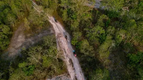
What elevates Bu Gia Map National Park beyond a standard scenic stop is its profound ecological significance as a crucial conservation zone. It is a place to preserve rare genetic resources, ensuring the safety of the Can Don and Soc Phu Mieng hydroelectric plants while serving scientific research and environmental education. Unlike the vertical drama of Ha Giang or the terraced symmetry of Sapa, Bu Gia Map National Park is defined by its fluid, evergreen moist forest ecosystem. Here, the experience is adventure-focused on the land and water alike—trekking through primary forests, camping by streams, and navigating jungle trails to reach pristine waterfalls that have remained largely untouched by modern development.
Best Time To Visit?
Visitors can explore Bu Gia Map National Park year-round, as each season reveals its own unique character. However, it is crucial to understand the two distinct seasonal patterns. The rainy season lasts from May to November, while the dry season runs from December to April.
However, the best time for the optimal outdoor experience is during the dry season, from December to April, when the weather is dry, roads are accessible, and the risk of rain is minimal, allowing for uninterrupted deep jungle trekking.
The Pristine Dry Season (December - April)
The period from December through April represents the classic "good weather window" for Southern Vietnam, and it is the most reliable and most recommended time for a visit tailored to trekking and wildlife spotting. During these months, rainfall drops significantly, skies are clearer, and temperatures hover between a comfortable 25°C and 28°C. The trails are firm, and the waterfalls, while lower in volume, are accessible. This is the prime season for camping by the streams, motorbiking the jungle trails, and photography, as the dry air keeps leeches and mosquitoes less active than in summer. For those seeking accessibility and comfort, this is the window to aim for.
The Lush Rainy Season (May - November)
From May through November, the tropical monsoon transforms the park. This is not to suggest the rainy season should be avoided; it simply requires different expectations. The landscape explodes into a hyper-vibrant green, and the waterfalls (like Dak Mai) reach their thunderous peak flow, surrounded by blooming wild fruits such as wild lychee, rambutan, and mango. For the flexible traveler who does not mind muddy boots and brief daily showers, the rainy season offers the park at its most lush, least crowded, and is the best time to try and spot breeding wildlife and birds in their full plumage.
Festivals & Local Calendar
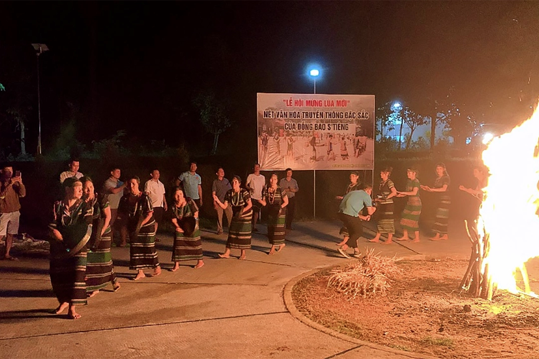
The cultural heartbeat of Bu Gia Map National Park is defined by the S'Tieng and M'nong ethnic groups. The most significant event is the New Rice Festival, a vibrant ritual where villagers gather around large jars of rice wine, dancing to the resonant echoes of gongs in thanks for a bountiful harvest. Another profound event is the Water Source Worship Ceremony, held to honor the spirits of the rivers and forests.
In 2024 and 2025, the traditional crafts of the S'Tieng people—specifically bamboo basket weaving and brocade weaving—were officially recognized as National Intangible Cultural Heritages. Travellers fortunate enough to align their visit with any of these festivals will encounter a Bu Gia Map that few tourists ever see: not just a quiet natural sanctuary, but a vibrant cultural landscape in full celebratory voice.
Must-See Places
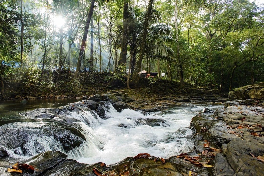
Dak Mai Waterfall: The Crown Jewel
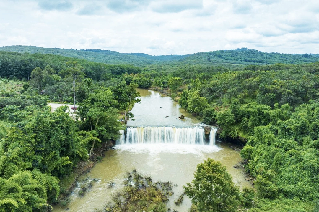
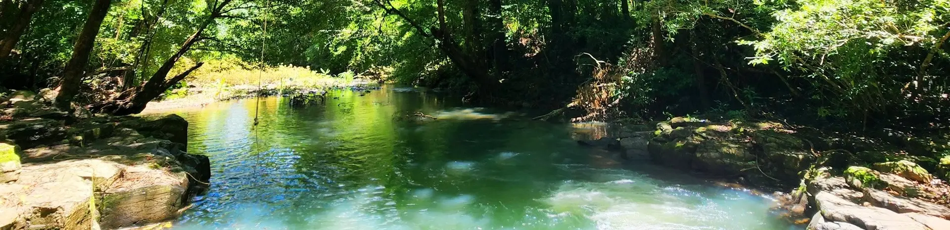
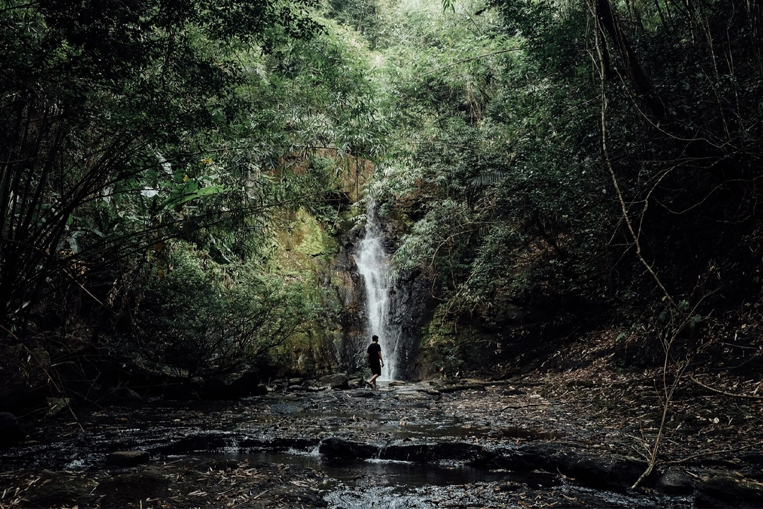
The journey to Dak Mai Waterfall is the park's crowning trekking achievement. cascading over a 15-meter wide rock face, plunging approximately 10 meters into a natural basin of about 300 square meters, creating a magnificent natural swimming pool. For the adventurous trekker, navigating the bamboo forests to reach this spot is a sophisticated "Price-to-Performance" way to experience the jungle's power. Notably, this was the base of operations for the Security Committee of Zone 10 in late 1966, adding a layer of historical depth to the natural beauty. In particular, the two sides of the waterfall have two caves, with a beautiful whirlpool flowing down between them—a memorable check-in point.
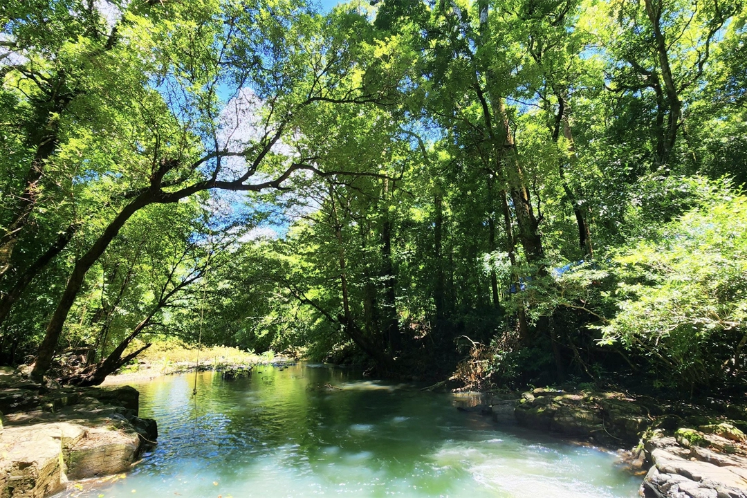
Dak Ca Stream & The Elephant Rock
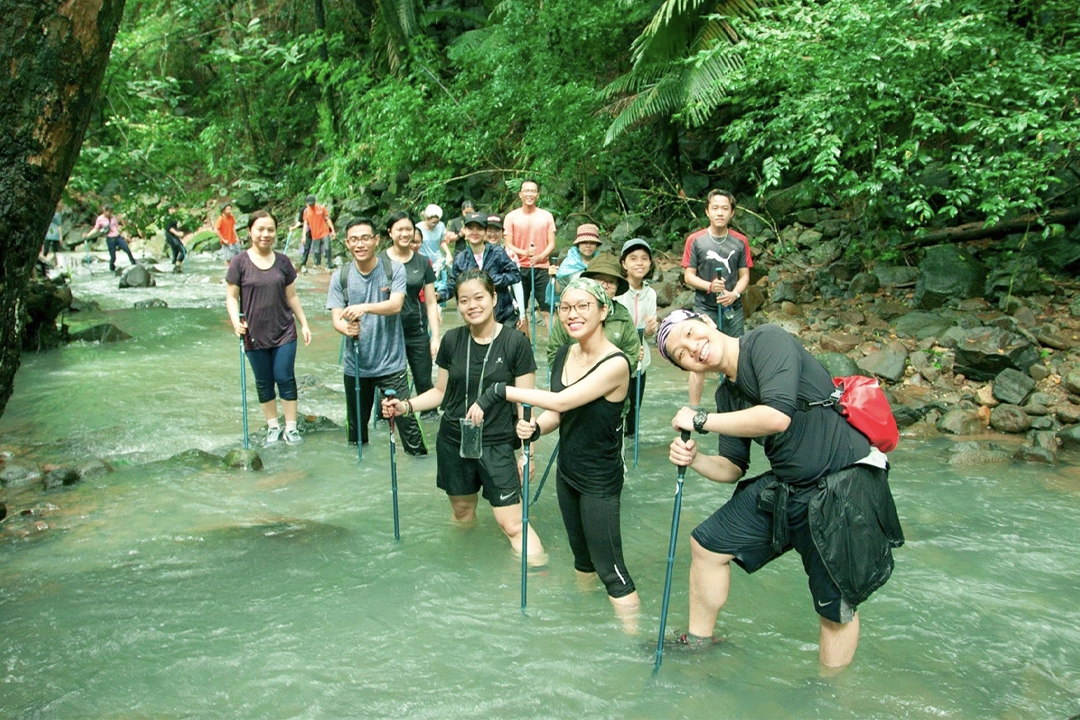
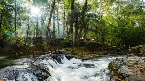
Winding through the vast orchards laden with cashew nuts (Binh Phuoc is renowned for its cashew production) lies the peculiar Dak Ca Stream. Here, geologically sculpted rock formations known as Elephant Rock sit quietly amidst the forest. Trails combined with the Dak Manh Stream route make this area a main trekking route, where one can witness ancient rocks lying along the banks like intricate veins of the landscape.
Bat Cave & Luu Ly Waterfall
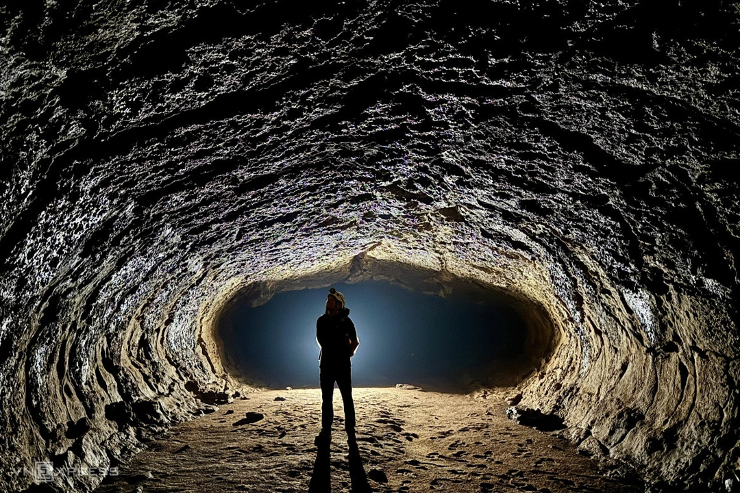
Away from the main stream, the park hides the Bat Cave, an intriguing subterranean feature, alongside the serene yet powerful Luu Ly Waterfall. These spots are less visited, offering a sense of true discovery for those who trek deeper into the protected zones. The Luu Ly route is often combined with the main 5 ecotourism trails, offering a glimpse into untouched primary forest.
Heaven Well & Dak Rot Waterfalls
Isolated within the lush greenery are the clear pools of Heaven Well (Gien Well) , a crystal-clear stream pool ideal for cooling off, and the cascading tiers of Dak Rot Waterfall and Dak Bo Waterfall . These locations are perfect for travelers looking to find a secluded spot away from the main trekking routes, offering an appealing glimpse into the intimate relationship between the geography and the endless water supply of the region.
Wildlife Rescue, Conservation and Development Center
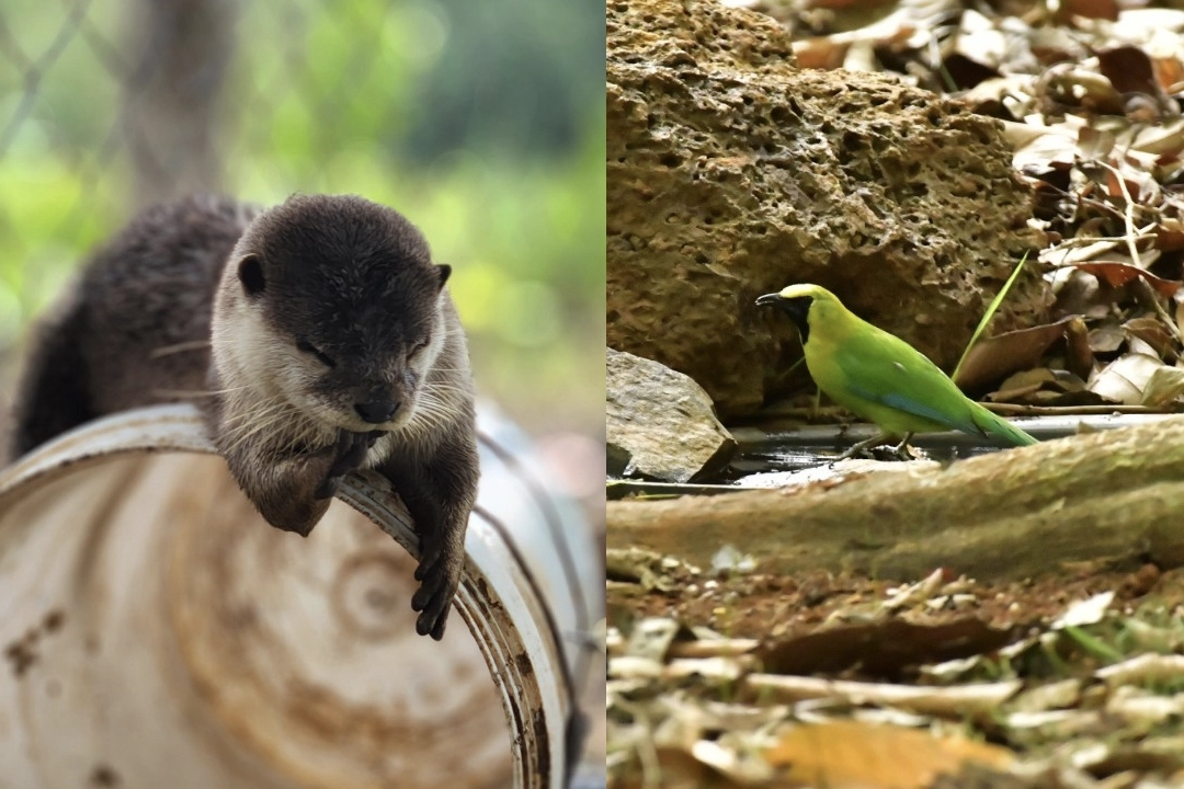
A significant mandatory stop for any conservation-focused traveler is the Wildlife Rescue, Conservation and Development Center. Here, visitors can observe firsthand the rare animal species such as the yellow-cheeked gibbon, black-footed langur, long-tailed monkey, pig-tailed monkey, peacock, golden mountain turtle, and clouded monitor lizard that are being cared for. This center has received, rescued, and released 323 wild animals of 30 different species into the wild, playing a mechanical necessity for the survival of species like the Sunda pangolin and the gaur.
Where to Stay: Authentic Sanctuary
Homestays in the Buffer Zone (S'Tieng & M'nong Villages)
For an authentic, travel-focused experience, staying in traditional S'Tieng or M'nong longhouses is essential. Villages in the buffer zones, such as those in Dak O commune, offer high-quality homestays where visitors can sleep on wooden floors overlooking the forest or rice paddies. These accommodations have been developed to provide private bathrooms and mosquito nets while maintaining their rustic elegance. Typical room rates here range from approximately 300,000 VND to 600,000 VND (12−24 USD) per night, often including close contact with the locals and home-cooked meals.
Generally, accommodations inside the core zone are not available. Most homestays are located on the outskirts or near the park entrance in the buffer zones. Basic amenities are standard, requiring visitors to be self-sufficient. For those wanting more fully equipped accommodations, Bu Gia Map is still developing; most options remain eco-lodges and guesthouses rather than hotels.
Camping Options (Organized)
Additionally, camping by the streams and in the grasslands has become a new popular experience. Bu Gia Map National Park offers opportunities for overnight camping, particularly for those on multi-day trekking or motorbike itineraries. Organized camping trips, typically booked through tour operators or local rangers, allow small groups to spend a night in the dense tropical forest near falls like Dak Mai, with tents, dry bags, and cooking equipment provided. The experience involves campfire evenings under the stars, trekking by day, and the unforgettable sensation of waking to the sound of the gibbons and the flowing stream.
Beyond the lake shore, specific grassland areas within the broader Binh Phuoc province are identified as camping-viable locations for those seeking an even more remote experience. However, wild camping independently within the national park boundaries is strictly not permitted; all camping should be arranged through registered operators or local park guides who understand environmental regulations and safety protocols. Camping is most feasible and pleasant during the dry season (December to April), when lower humidity and minimal rainfall reduce discomfort and insect risk.
Recommended Itinerary
1-Day Itinerary (The Highlights):
- Morning: Arrival & Wildlife Rescue Center visit.
- Late Morning: Trek to Elephant Rock & Dak Ca Stream.
- Afternoon: Trek to Dak Mai Waterfall for swimming.
2-Day Itinerary (The Expedition):
- Day 1: Start at Park HQ. Trek via Dak Manh Stream to Dak Ca Stream. Camp overnight near Elephant Rock or designated grassland site. Evening campfire with local rangers.
- Day 2: Morning trek to Luu Ly Waterfall and Bat Cave. Afternoon visit Dak Mai Waterfall and the historical zone (the end point of the VK96 oil pipeline) before returning.
Practical Travel Tips
.webp)
1. Book a tour or hire a guide
If this is your first time trekking in Bu Gia Map, you should book a tour with a reputable travel company or hire a guide. Besides having companions throughout the trek instead of going alone, you will also learn a lot from the guide. In addition, your safety will be ensured throughout the journey.
2. Physical and mental preparation
Before you depart, prepare yourself physically and eat a balanced diet to strengthen your health and mental state. According to the experience of trekking in Bu Gia Map for beginners, these two factors are extremely important for a smooth trekking journey.
3. Check the weather forecast
Checking the weather is extremely important in the experience of trekking in Bu Gia Map for beginners. You should check the weather forecast before you go to ensure you depart during a time of cool, pleasant weather. Avoid going during the rainy season as the roads will be very slippery and dangerous!
4. Bringing Essential Items
Based on our experience trekking in Bu Gia Map National Park, you should prepare enough clothes for the trip and a good pair of trekking shoes with good grip, along with other accessories such as hats, gloves, etc. Especially since long walks can easily lead to dehydration, bring plenty of water and some snacks to eat along the way. In addition, essential medical supplies such as medicine, bandages, antiseptic alcohol, etc., are also indispensable. Finally, remember to bring personal items such as a toothbrush, toothpaste, sunscreen, power bank, etc.