Typhoon Matmo Strengthens as storm No. 11 and Directly Impact Northern Vietnam

Current Status and Initial Forecast of Matmo Typhon on morning of 4th Oct
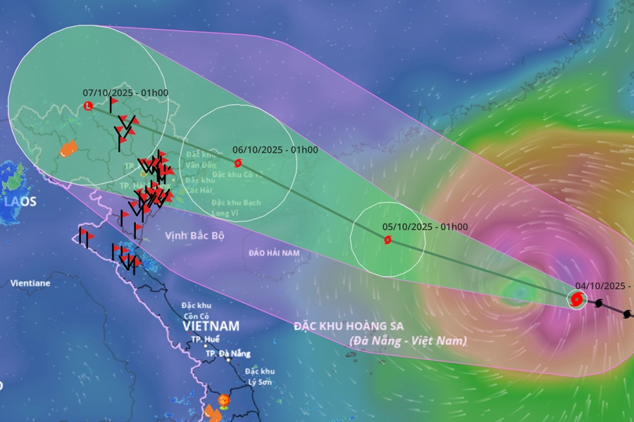
As of 7:00 AM on October 4, Typhoon Matmo (designated as Storm No. 11 in Vietnam) has strengthened to Level 11, with sustained winds of 103–117 km/h and gusts up to Level 14. The storm's center is located approximately 530 km east-northeast of the Paracel Islands (Hoang Sa). It continues to move rapidly in a West-Northwest direction at 20–25 km/h.
Favorable conditions in the East Sea, including warm sea temperatures (around 29°C) and low wind shear, are expected to fuel further intensification. The storm is projected to accelerate as it progresses.
Detailed Forecast: Path and Intensity of Matmo Typhon
By 4:00 AM on October 5
- Location: 19.7°N latitude, 112.2°E longitude, in the northern East Sea, about 130 km east of the Leizhou Peninsula (China).
- Intensity: Sustained winds Level 13, gusts Level 16 (very strong typhoon).
- Movement: West-Northwest at 20–25 km/h.
Landfall Projection
- Expected Time: Around dawn on October 6.
- Location: Quang Ninh Province, Vietnam.
- Pre-Landfall Effects: From the evening of October 5, coastal areas from Quang Ninh to Ninh Binh will experience gradually strengthening winds.
Impacts and Hazards
Marine Conditions
North East Sea: Winds Level 8–10, increasing to Level 11–13 near the storm's center, with gusts up to Level 16. Waves will reach 4–6 meters, rising to 6–8 meters near the eye—extremely rough and destructive seas capable of sinking large vessels.
Northern Gulf of Tonkin (including Bach Long Vi, Van Don, Co To, Cat Hai, and Hon Dau Islands):
- From the afternoon of October 5: Winds Level 6–7, rising to Level 8–9.
- From the evening of October 5: Winds Level 8–9, with areas near the storm path experiencing Level 10–11 winds and Level 14 gusts. Waves will be 2–4 meters, increasing to 3–5 meters in affected zones.
Land Impacts
- Wind Damage: From the night of October 5, inland areas from Quang Ninh to Ninh Binh will face winds Level 6–8, escalating to Level 9–10 near the storm's path. These conditions pose a high risk of felling trees, damaging houses, and toppling power poles.
- Storm Surge: Coastal regions of Quang Ninh and Hai Phong may see a storm surge of 0.4–0.6 meters, raising the threat of flooding in low-lying areas and river estuaries.
- Rainfall: From the night of October 5 through the night of October 7, heavy to very heavy rain (100–200 mm, locally over 300 mm) is forecasted for Northern Vietnam, Thanh Hoa, and Nghe An. Mountainous and midland areas of the North could receive 150–250 mm, with isolated totals exceeding 400 mm. Intense rainfall rates may exceed 200 mm/3 hours, elevating risks of flash floods, landslides, and urban inundation
Warnings and Precautionary Measures
- Disaster Risk Level: 3 (high risk) for affected marine and coastal zones.
- Residents and Authorities: Urged to reinforce infrastructure, secure property, and evacuate vulnerable areas. Coastal communities should prepare for storm surge and wave impacts.
- Travel and Tourism: All marine activities in the Gulf of Tonkin and East Sea should be suspended. Travelers to Northern Vietnam should monitor updates and avoid coastal and mountainous regions during the storm period.
Tourism and Precautionary Measures
Potential Disruption to Halong Bay Tours and Hanoi - Cat Ba transfer service
While no official bans have been announced yet, similar past typhoons (e.g., Tapah and Ragasa) led to temporary suspensions of cruise operations in Halong Bay, Lan Ha Bay, and Bai Tu Long Bay. If Matmo follows its forecasted path, tours departing from October 4–6 may be affected. Travelers are advised to:
- Contact cruise companies for real-time updates.
- Reschedule itineraries if planning visits to Northern coastal or mountainous areas during this period.
- Monitor official weather alerts for any sea bans or safety notices.
There is a high probability that Ferry, Speed Boat, and Cable Car services between Cat Ba Island and the Mainland will be suspended tomorrow, October 5th, due to expected adverse weather conditions. Therefore, all passengers are strongly recommended to return to the Mainland by the end of today. Travelers can explore the following transfer options from Cat Ba to Hanoi or Ninh Binh:
- Cat Ba to Hanoi bus
- Cat Ba to Hanoi private car
- Cat Ba to Hanoi airport transfer service
- Cat Ba to Ninh Binh bus
Unusually Active Typhoon Season
The East Sea has recorded an exceptionally high number of storms this year. As of October, there have been 10 typhoons and 4 tropical depressions, surpassing the average of 4–6 storms by this time in recent years. Matmo is set to become the 11th typhoon of 2025, highlighting an intense and prolonged typhoon season.

Typhoon Bualoi causes heavy rain and flooding in many northern and central provinces, significantly impacting tourist travel.
Stay Informed
Residents and travelers in Northern Vietnam and the East Sea region should closely follow updates from the National Center for Hydro-Meteorological Forecasting and local authorities. Preparedness is key to minimizing risks from Matmo’s anticipated impacts.