Typhoon Kalmaegi Intensifies Rapidly, Posing Severe Threat to Vietnam's Central Coast
Typhoon Kalmaegi, which is expected to become the 13th typhoon of the 2025 season, is rapidly intensifying over the Pacific Ocean and could reach super typhoon status as it approaches the Philippines. Authorities are warning of significant impacts on Vietnam, particularly in central coastal regions and offshore areas, with potential disruptions to travel and maritime activities.
Recent Developments and Current Status
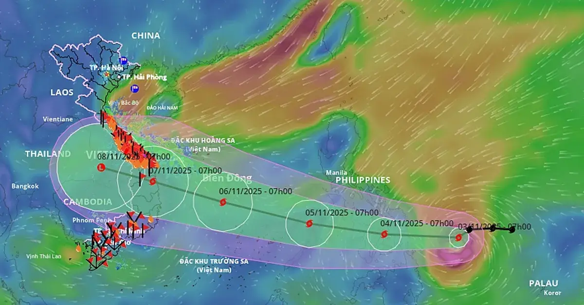
As of 7:00 AM on November 3, 2025, Typhoon Kalmaegi was located approximately 430 km east of Guiuan in Eastern Samar, Philippines. It has intensified to a Category 11 storm, with maximum sustained winds of 110 km/h and gusts reaching up to 135 km/h. In just over a day, the typhoon has strengthened by three categories, highlighting its rapid development.
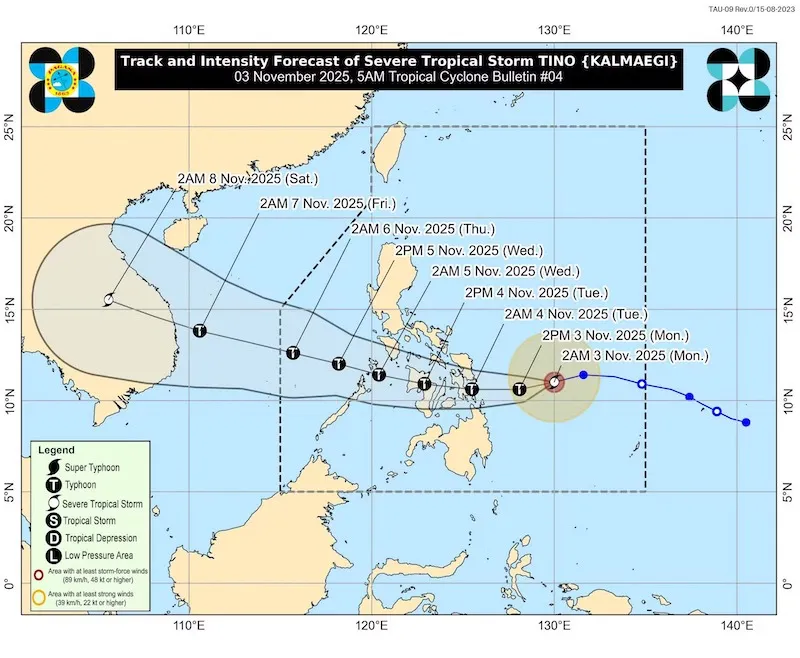
The Philippine Atmospheric, Geophysical and Astronomical Services Administration (PAGASA) has emphasized that warm sea surface temperatures and favorable atmospheric conditions are fueling this intensification, with the possibility of it becoming a super typhoon.
Forecast: Path and Intensity
- Immediate Outlook: The typhoon is moving westward at a speed of about 20 km/h and is expected to cross central Philippines by the morning of November 4. It is forecast to intensify to Category 12 with gusts up to Category 15 during this period.
- Entry into the East Sea: By the evening of November 4 or early November 5, Kalmaegi will enter the East Sea (Biển Đông), officially becoming the 13th typhoon of the season. It is projected to move west-northwest at 20–25 km/h, reaching peak intensity on November 6. At that time, it could strengthen to Category 14, with gusts exceeding Category 17, while positioned about 400 km off the coast of Gia Lai Province, Vietnam.
- Landfall Projection: The typhoon is expected to make landfall in Central Vietnam, likely between Da Nang and Quang Ngai, on the morning of November 7. While it may weaken slightly before landfall, it could still strike with considerable force due to warm sea conditions and minimal atmospheric interference. Continuous monitoring is advised as the situation evolves.
Impact Forecast for Vietnam
Sea Conditions
- From the afternoon of November 4, the eastern part of the central East Sea will experience gradually strengthening winds, initially at Level 6–7, rising to Level 8–9. Areas near the typhoon's center could see winds of Level 10–12, with gusts of Level 14–15 and waves of 5–7 meters, resulting in very rough seas.
- Between November 5–6, the central East Sea (including the Spratly Islands) and offshore areas from Da Nang to Khanh Hoa will be severely affected, with winds potentially reaching Level 12–14, gusts over Level 17, and waves soaring to 8–10 meters. This will create extremely dangerous conditions for maritime activities.
Land Impact
- Central Vietnam: The region from Da Nang to Quang Ngai is at highest risk, with potential for strong winds, heavy rainfall, and storm surges during landfall on November 7. Flooding and landslides are possible in low-lying and coastal areas.
- Northern and Southern Vietnam: Based on current projections, direct impacts are less likely in the north and south. However, indirect effects such as increased wave action or scattered rainfall cannot be ruled out, especially if the typhoon's track shifts. Authorities are urging residents in central provinces to prepare for evacuation if necessary.
Recommendations for Travelers
- Stay Informed: Continuously monitor updates from official sources like the National Center for Hydro-Meteorological Forecasting (Vietnam) and PAGASA (Philippines). Weather conditions can change rapidly.
- Adjust Plans: If traveling to or in coastal or island areas—particularly in the Central Vietnam (e.g., Quang Binh, Hue, Da Nang, Hoi An and Quy Nhon to Khanh Hoa)—postpone or cancel outdoor activities, beach trips, and island tours from November 4 onward.
- Transportation Disruptions: Expect delays or cancellations for flights, ferries, and boat services in affected regions. Confirm schedules with carriers before departure.
- Safety First: Avoid sea travel and coastal areas during the storm. If already in an at-risk location, follow local advisories and seek shelter in secure buildings.
Conclusion
Typhoon Kalmaegi represents a significant threat to Vietnam's central coast and the East Sea, with its rapid intensification and potential for severe impacts. Residents and travelers should remain vigilant and prioritize safety. Further updates will be provided as the typhoon approaches.
Source: Integrated data from PAGASA, Vietnam's National Center for Hydro-Meteorological Forecasting, and weather experts as of November 3, 2025.