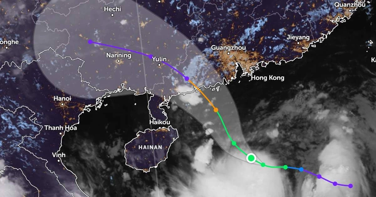
Storm No. 7 Tapah forecast path for the next 24 hours
Typhoon No. 7, Tapah, is currently strong at level 10-11, with level 13 gusts, and is moving quite rapidly. It is expected to make landfall in Guangdong province (China) this morning and gradually weaken. From the afternoon and night of September 9th, the Northern of Vietnam region will experience widespread rain in the mountainous and midland areas.
Forecast path of Storm Tapah
According to the National Center for Hydro-Meteorological Forecasting, as of 7:00 AM today (September 8th), Typhoon No. 7 Tapah was located off the coast of Guangdong province (China), with an intensity of level 11 and gusts of level 13. It is moving Northwest at 20-25 km/h. This morning, the typhoon will make landfall and gradually weaken.
It is forecast that in the next 12 hours, the typhoon will change direction, moving Northwest at 20-25 km/h, and gradually weaken into a tropical depression. By 19:00, the center of the tropical depression will be overland in Guangxi province (China), with an intensity of level 7 and gusts of level 9.
In the following 12 hours, the storm will move West-Northwest at 20-25 km/h and gradually weaken into a low-pressure area overland in Guangxi province (China).
Meteorological experts note that although Vietnam is not directly affected by the storm's circulation, areas on the far outskirts of the circulation, such as the Gulf of Tonkin and the eastern coastal areas of the North, may experience thunderstorms, tornadoes, and strong gusts.
Expected Effects of Typhoon Tapah on Northern Vietnam's Weather
From tomorrow (September 9th) to the night of September 10th, the mountainous and midland regions of the North are likely to experience a widespread heavy rain event with rainfall amounts of 70-150mm, and locally over 300mm in some places. There is a warning of risk for heavy rain intensity (>100mm/3h). During thunderstorms, there is potential for tornadoes, lightning, hail, and strong gusts.
From September 11th, as the low-pressure area dissipates, rain in the North will decrease; from September 12th-14th, the weather will be clear and cool.
Due to the influence of Typhoon No. 7, the sea area north of the North East Sea region has strong winds of level 7-8, with areas near the storm center experiencing level 10-11 winds and level 13 gusts; waves are 4-6m high, and the sea is very rough. Vessels operating in the aforementioned dangerous areas are likely to be affected by thunderstorms, tornadoes, strong winds, and large waves.
Thus, from the beginning of the year until now, the East Sea has seen 7 storms. It is forecast that from now until the end of the year, the East Sea could welcome an additional 5-7 storms or tropical depressions, of which 2-3 will directly affect the mainland, mainly from the Central region southward.
Will Halong Bay tours be affected by Tapah Typhoon No. 7?
As of the morning of September 8th, there has been no announcement from the management boards of Halong Bay, Lan Ha Bay, and Bai Tu Long Bay regarding restrictions on vessels operating in the bay area. Halong Bay tours on September 8th are still departing as usual until further notice.
Recommend Hlong Bay day tours running on September 9th: