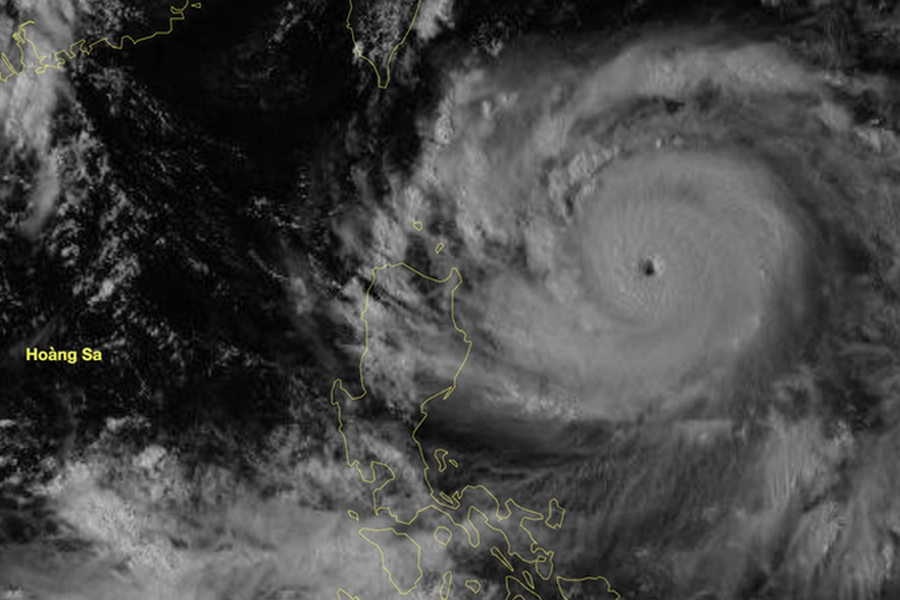
Super typhoon Ragasa update 2025
Super Typhoon Ragasa has reached its maximum intensity at Category 17 and is forecasted to enter the East Vietnam Sea tonight, becoming the 9th typhoon to affect Vietnam in 2025. By the morning of 25 September, it is expected to enter the Gulf of Tonkin and subsequently make direct landfall over Vietnam.
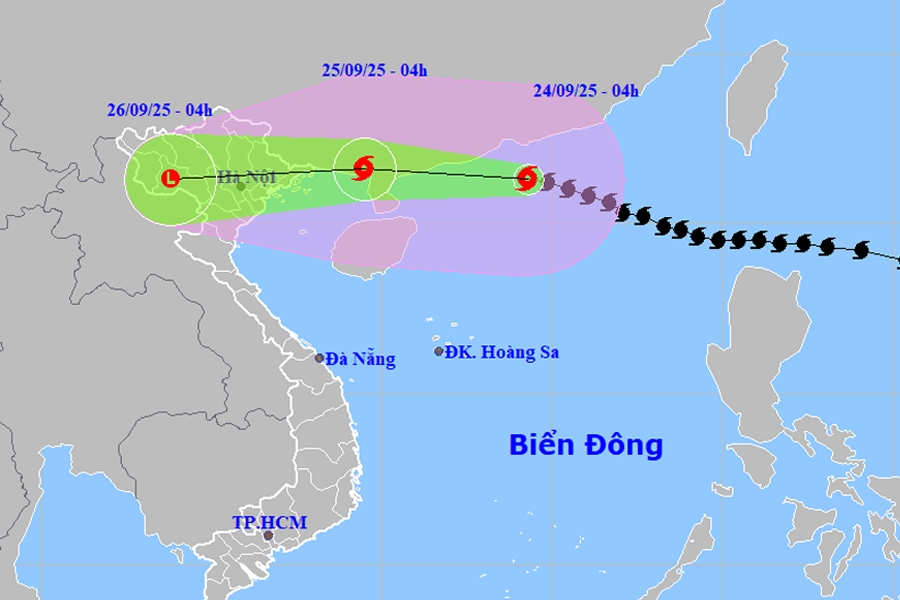
Typhoon Ragasa Landfall Update on 25th Sept
According to the Guangdong Provincial Meteorological Observatory, Typhoon Ragasa made landfall on Hailing Island, Yangjiang City at approximately 17:00 on 24 September. At landfall, maximum sustained winds near the center reached Category 13 (40 m/s). The system is forecasted to continue moving westward at about 20 km/h.
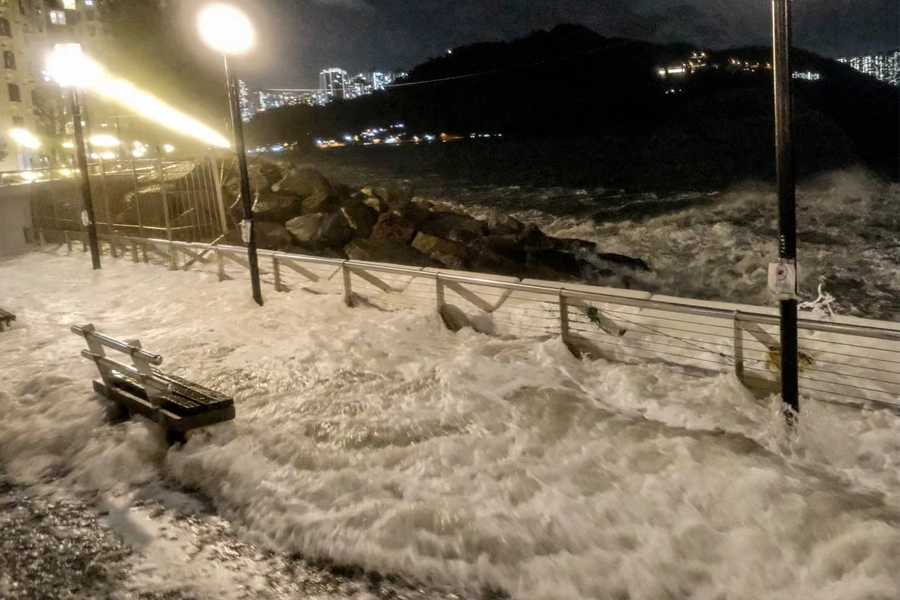
Waves crash into the Heng Fa Chuen residential district as Super Typhoon Ragasa approaches Hong Kong. Photograph: Tommy Wang/AFP/Getty Images
As a result, the typhoon did not make landfall in Vietnam or enter the Gulf of Tonkin. However, due to its intense circulation, indirect impacts will affect northern Vietnam and the Gulf of Tonkin.
Impacts on Marine and Coastal Areas
Marine Conditions
- Northwestern South China Sea: Winds Category 6–8, gusts to Category 10, waves 3.0–5.0 m; rough seas.
- Northern Gulf of Tonkin (including Bach Long Vi, Van Don, Co To, Cat Hai, and Hon Dau Island): On 25 September, winds Category 6–7, waves 2.0–3.0 m; near the storm path, winds Category 8–9, gusts to Category 11, waves 3.0–4.0 m; very rough seas.
- Coastal and Inland Winds
- Coastal areas from Quang Ninh to Hai Phong: Winds increasing to Category 6–7, with Category 8 near the center, gusts Category 9–10.
- Inland northeastern regions: Winds Category 5, locally Category 6, gusts Category 7–8.
- Rainfall and Associated Hazards
- From early 25 September through 26 September, heavy to very heavy rainfall (150–300 mm, locally over 450 mm) is expected in the Northern Delta, Thanh Hoa, and Nghe An provinces.
Risks include
- Urban flooding in low-lying areas.
- Flash floods in small streams and landslides on slopes.
- Thunderstorms with tornadoes, lightning, and strong gusts.
- A flood wave is likely on rivers in Northern Vietnam, Thanh Hóa, and Nghệ An from today until 27 September.
Weather Conditions in Hanoi under impact of Typhoon Ragasa
On 25 September, Hanoi experiences rain from morning, intensifying to moderate/heavy showers with scattered thunderstorms by afternoon; locally very heavy rain. Conditions are expected to normalize by 26 September, with mild sunshine.
Will Halong Bay tours be affected by Typhoon Ragasa No. 9?
The management boards of Ha Long Bay and Lan Ha Bay have issued a sea ban effective September 25, leading to the temporary suspension of all cruise tour operations in the area on 25th Sept. This decision is currently restricted to September 25, with no official ban yet declared for September 26.
Operational Outlook for September 26
Due to Typhoon Ragasa making landfall in China on the afternoon of September 24 without entering the Gulf of Tonkin, it is highly likely that Ha Long Bay tourism activities will resume on September 26. Continuous monitoring of official updates is recommended for confirmation.
Recommend Hlong Bay day tours running on September 26th:
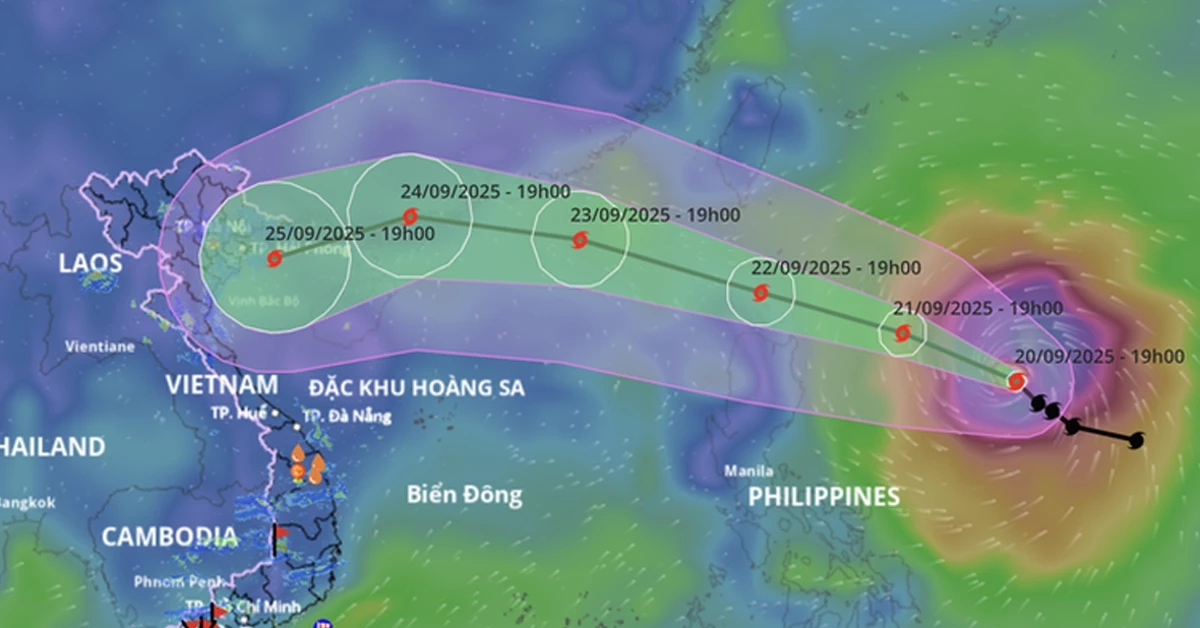
Current Status and Movement of Typhoon Ragasa Update on Morning of 24th Sept
According to the Vietnam National Center for Hydro-Meteorological Forecasting, as of early morning 24 September, Super Typhoon Ragasa maintained its intensity at Category 15-16 (167-201 km/h sustained winds), with gusts exceeding Category 17. It was located approximately 650 km east of Mong Cai (Quang Ninh Province), generating severe winds and heavy rainfall in southern Guangdong, China. The typhoon is forecasted to make landfall in Vietnam around noon to afternoon on 25 September.
Movement is west-northwest at a speed of about 20 km/h.
Forecasted Trajectory and Intensity of Ragasa
Meteorologists classify Ragasa as one of the strongest super typhoons ever recorded in the East Vietnam Sea. It is projected to maintain its peak intensity (Category 17, gusts above Category 17) through 23 September, comparable to or exceeding the strength of Typhoon Yagi (Storm No. 3) in 2024.
By the morning of 25 September, Ragasa is expected to enter the Gulf of Tonkin with slightly reduced intensity (Category 13 - 14, gusts up to Category 17), directly impacting coastal regions from Quảng Ninh to Hà Tĩnh.
Both international and Vietnamese forecasting agencies note that Ragasa has an extensive circulation. Its path and intensity remain complex due to interaction with an early-season cold air mass. A deviation of 50 - 100 km could significantly alter its impact range and severity.
Detailed 24 - 72 Hour Forecast
24-Hour Forecast
Over the next 24 hours, Ragasa will continue moving west-northwest at 20–25 km/h while gradually weakening. By 04:00 on 25 September, the typhoon’s center is expected to be near the coastal area of Guangxi Province, China, about 150 km east of Móng Cái (Quảng Ninh), with winds reduced to Category 11 and gusts to Category 13.
48-Hour Forecast and Weakening Trend
In the following 24 hours (25–26 September), the system will shift westward at 25–30 km/h, downgrading to a tropical depression and eventually a low-pressure area. By 04:00 on 26 September, the tropical depression is projected to be over the northwestern region of Vietnam.
Meteorologists note that Ragasa maintained Category 15–16 intensity this morning but will weaken due to friction with terrain over southern Guangdong and intrusion of dry air from a cold air mass to the north. Upon entering the Gulf of Tonkin, winds are expected to decrease to Category 11–12.
Landfall is anticipated between Quảng Ninh and Hưng Yên provinces around midday to afternoon on 25 September.
Marine and Coastal Impacts
Northern South China Sea: Winds of Category 10–13, with Category 14–16 near the typhoon’s center, gusts above Category 17, waves over 10 meters, and violently rough seas.
Eastern Gulf of Tonkin (including Bach Long Vi Island): Winds increasing to Category 6–7 from noon today, gusts to Category 9.
Northern Gulf of Tonkin (including Bach Long Vi, Van Don, Co To, Cat Hai, and Hon Dau island): Winds strengthening to Category 8 overnight, waves 2–4 meters; near the typhoon’s path, winds of Category 9–11, gusts to Category 13, waves 3–5 meters, with very rough seas.
Quang Ninh coastal areas: Storm surge of 0.4–0.6 meters, high risk of embankment erosion, damage to aquaculture infrastructure, and moored vessels due to strong winds, surge, and large waves.
Inland Weather Warnings
From early morning 25 September, coastal areas from Quang Ninh to Ninh Binh will experience winds increasing to Category 6–7, with Category 8–9 near the center, gusts to Category 11. Inland northeastern regions may see Category 5 winds, locally Category 6, gusts Category 7–8.
From tonight (25th Sept) through 26 September, heavy to very heavy rainfall (100–250 mm, locally over 400 mm) is forecasted for the Northern Delta, Thanh Hoa, and Nghe An provinces. This raises risks of urban flooding, inundation in low-lying areas, flash floods in small streams, and landslides on slopes.
Due to the typhoon’s broad circulation, thunderstorms, tornadoes, and strong gusts may occur both before and during landfall. Continuous monitoring of official updates is advised.
The effects of the typhoon on tourism are expected to occur in three main phases:
Phase 1: Typhoon Entering the Gulf of Tonkin
Expected period: Early morning 24/09 - Night 25/09
Based on past experience, it is highly likely that all tourist vessels in Halong Bay, Lan Ha Bay, and Bai Tu Long Bay will be prohibited from departing between 24 and 26 September (official notice pending).
➤ If you have a cruise tour scheduled in these areas, please contact your cruise company for the most accurate updates regarding departure status and related policies in case of cancellations.
Phase 2: Typhoon Making Landfall in Northern Vietnam
Expected period: 26 - 27/09
All tourism activities across Northern Vietnam are expected to be restricted due to heavy rainfall and strong gusts.
➤ As a result, daily tours departing from Hanoi and Ninh Binh will be temporarily postponed.
Phase 3: Post-Storm Residual Rainfall
Expected period: 28 - 30/09
The typhoon’s residual circulation is forecast to cause heavy rainfall, potentially leading to flooding and flash floods in mountainous and midland regions of Northern Vietnam.
➤ Travelers planning to visit Ha Giang, Sapa, or participate in trekking tours in mountainous areas are strongly advised to reschedule their itineraries and avoid regions prone to flash floods.