Typhoon Fengshen to Enter East Vietnam Sea becoming 12th Storm of 2025
A tropical depression over the eastern sea of central Philippines has intensified into Typhoon Fengshen, which is forecast to enter the East Vietnam Sea in the coming days. This will be the 12th typhoon to affect the region in 2025, with potential impacts on marine conditions and inland weather due to an interacting cold air mass.
Current Status and Movement of Typhoon Fengsheng
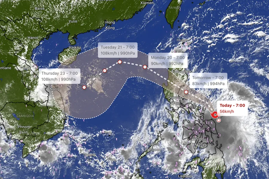
As of 7 AM on October 18, the center of Typhoon Fengshen was located at approximately 13.1°N latitude and 126.5°E longitude, over the eastern waters of central Philippines. Maximum sustained winds were at Category 8 (62–74 km/h), with gusts up to Category 10. The typhoon is moving westward at a speed of about 20 km/h.
Forecasted Path and Intensity
- By 7 AM on October 19: The typhoon is expected to be near the eastern coast of Luzon Island, Philippines, turning west-northwest with winds strengthening to Category 9 and gusts to Category 11.
- Afternoon/Evening of October 19: Fengshen will cross the Luzon Peninsula and enter the East Vietnam Sea.
- By 7 AM on October 20: The typhoon is forecast to be over the sea east of the northern East Vietnam Sea, with sustained winds at Category 9 and gusts to Category 11.
- By 7 AM on October 21: It may intensify to Category 10 with gusts to Category 12 over the northern East Vietnam Sea.
- Beyond 72 hours: The system is likely to shift southwestward at about 10 km/h and could strengthen further.
Impacts on Marine and Coastal Areas
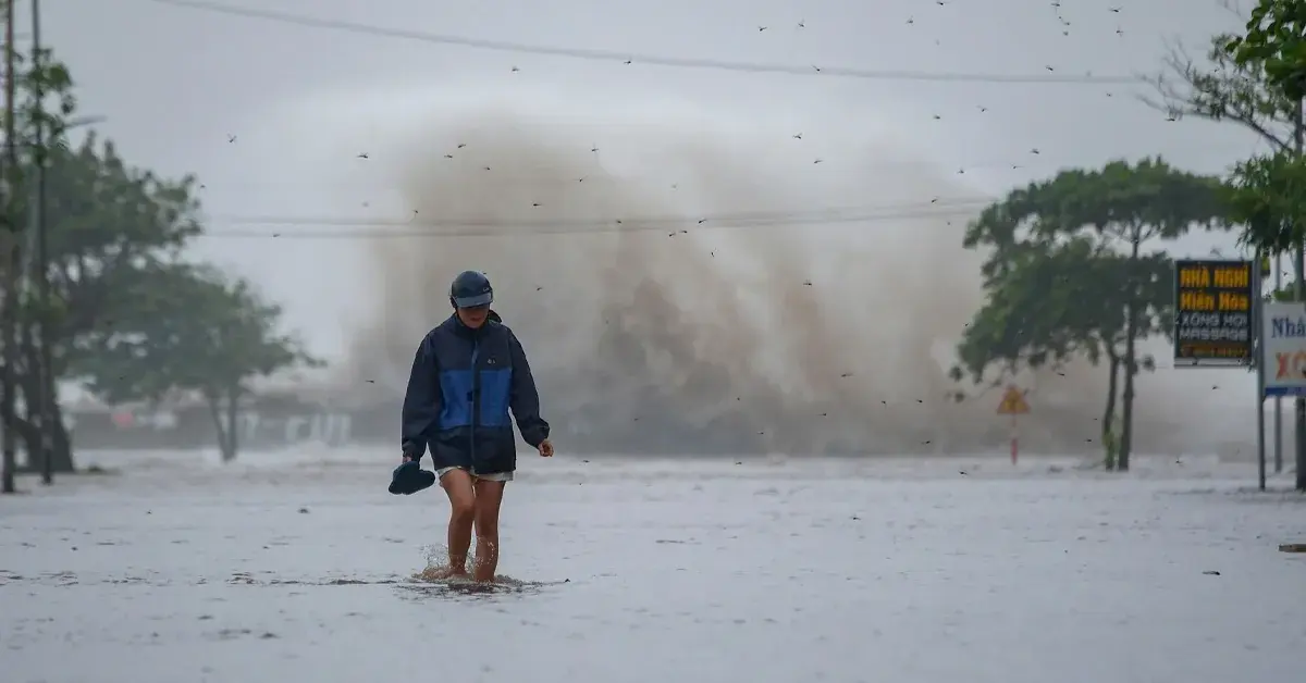
- From October 19, the eastern part of the northern East Vietnam Sea will experience winds increasing to Category 6–7, with areas near the typhoon’s center reaching Category 8–9 and gusts to Category 11. Waves will be 2.5–5 meters high, resulting in very rough seas.
- Between October 20 and 22, the northern East Vietnam Sea, including the Paracel Islands (Hoang Sa), could have winds of Category 10–11 with gusts up to Category 13.
- Vessels in affected areas are advised to take precautions against strong winds, high waves, thunderstorms, and whirlwinds.
Inland Weather and Cold Air Influence
- A cold air mass is moving southwards and will affect northeastern Vietnam from early October 19. It will intensify and spread to other regions (north-central, parts of northwest and central-central) from October 20 to 22, marking the first northeast monsoon of the 2025–2026 winter season.
- Northern Vietnam, including Hanoi, will experience scattered showers and thunderstorms. Temperatures will drop, with the north turning cool from the evening of October 19 and cold from the night of October 20.
- Lowest temperatures: 19–21°C in the northern delta, 17–19°C in midlands and mountainous areas, and below 16°C in high mountains. Hanoi’s lows will be 19–21°C.
- The cold air may cause Typhoon Fengshen to weaken over the East Vietnam Sea, but its circulation could still bring heavy rain to central provinces from October 23 to 26, raising risks of urban flooding, flash floods, and landslides.
Historical Context
Typhoon Fengshen is named after the Chinese god of wind, symbolizing nature’s power. In 2008, a typhoon with the same name caused significant damage in the Philippines, resulting in hundreds of casualties.
Recommendations for Travelers
As a tour company, we prioritize your safety and advise the following based on the typhoon’s forecast and impacts:
Phase 1: Typhoon Entering East Vietnam Sea (October 19–20)
- Coastal areas, especially Halong Bay, Lan Ha Bay, and Bai Tu Long Bay, may experience sea bans and suspension of cruise tours.
- If you have a cruise tour scheduled during this period, contact your cruise operator for updates on departures and cancellation policies.
- Recommended tours during this phase should be avoided; reschedule to a safer date.
Phase 2: Typhoon Influencing Weather (October 20–22)
- Inland tours in northern Vietnam, including day trips from Hanoi, may be affected by heavy rain, strong winds, and thunderstorms.
- Urban flooding is possible in low-lying areas. Avoid non-essential travel and monitor official updates.
- Tours in mountainous regions (e.g., Sapa, Ha Giang) should be postponed due to risks of flash floods and landslides.
Phase 3: Post-Storm Residual Effects (October 23–26)
- Residual rainfall may cause continued flooding in central provinces and mountainous areas.
- Trekking and adventure tours in flood-prone zones should be rescheduled.
- Coastal tourism is likely to resume gradually, but confirm with local authorities and tour providers before planning activities.
General Advice
- Monitor updates from the Vietnam National Center for Hydro-Meteorological Forecasting.
- Dress appropriately for cold weather in northern regions, with layers and waterproof gear.
- For any booked tours, maintain communication with your tour provider for real-time adjustments.
- Consider alternative indoor activities or delay travel to affected areas until conditions stabilize.
Stay safe and informed as we navigate this weather event together. For further assistance, contact our customer support team.